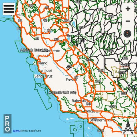
The i-Hunting app includes California Hunt Planner with vector topo maps, public lands, parcels, hunt zones, elevation contours and several other map layers designed to make hunt planning easier. The hunt app includes all advanced features of a standalone hunt GPS unit. The hunting GPS maps for California are fully customizable. All individual hunt map layers can be enabled selectively or downloaded for offline use.
California Hunt Planning Layers
California Hiking Trail Maps
The i-Hunting topo maps include detailed topographic contour maps, trail maps, spot elevations and other structures for all national and state parks in California. All the trail maps are fully vector, can be downloaded offline to the device. Vector hiking topo maps are reduced size maps, that can be zoomed in without any pixelation and take very little space on the device.
- Cabrillo National Monument Topo and Trail Map
- Castle Mountains National Monument Topo and Trail Map
- Cesar E. Chavez National Monument Topo and Trail Map
- Channel Islands National Park Topo and Trail Map
- Death Valley National Park Topo and Trail Map
- Devils Postpile National Monument Topo and Trail Map
- Eugene O'Neill National Historic Site Topo and Trail Map
- Fort Point National Historic Site Topo and Trail Map
- Golden Gate National Recreation Area Topo and Trail Map
- John Muir National Historic Site Topo and Trail Map
- Joshua Tree National Park Topo and Trail Map
- Kings Canyon National Park Topo and Trail Map
- Lassen Volcanic National Park Topo and Trail Map
- Lava Beds National Monument Topo and Trail Map
- Manzanar National Historic Site Topo and Trail Map
- Mojave National Preserve Topo and Trail Map
- Muir Woods National Monument Topo and Trail Map
- Pinnacles National Park Topo and Trail Map
- Point Reyes National Seashore Topo and Trail Map
- Port Chicago Naval Magazine National Memorial Topo and Trail Map
- Redwood National Park Topo and Trail Map
- Rosie the Riveter/World War II Home Front National Historical Park Topo and Trail Map
- San Francisco Maritime National Historical Park Topo and Trail Map
- Santa Monica Mountains National Recreation Area Topo and Trail Map
- Sequoia National Park Topo and Trail Map
- Whiskeytown-Shasta-Trinity National Recreation Area Topo and Trail Map
- World War II Valor in the Pacific National Monument Topo and Trail Map
California public and private land stats
| Government Lands | 131321.65 square miles |
| Percent Government Lands | 82.98 percent |
| Private Lands | 26933.18 square miles |
| Percent Private Lands | 17.02 percent |
California Hunting Regulations
The following website contains hunting regulations/seasons and details on purchasing / acquiring hunting /fishing licenses / permits. Please visit the following website directly to find more details regarding hunting regulations for California